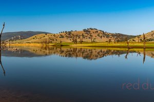
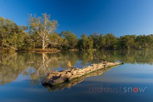
Upper Murray River vista at Gadd's Bend, located near Walwa on the Murray River. Upper Murray, Victoria, Australia.
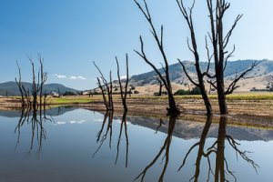
An Upper Murray River vista photographed during drought (2016). The original course of the Murray River is visible due to the low level of Lake Hume, NSW, Australia
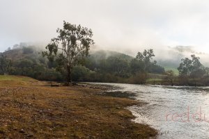
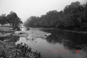
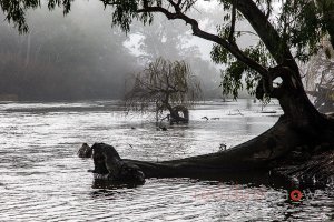
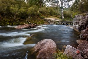
A misty winter's morning on the Upper Murray River at Gadds Bend near Walwa. Located downstream of Walwa on the Murray River. Upper Murray, NSW, Australia.
Morning Mist at Gadds Bend, camping. Located near Walwa on the Murray River. Upper Murray, Victoria
Morning Mist at Gadds Bend, camping. Located near Walwa on the Murray River. Upper Murray, Victoria
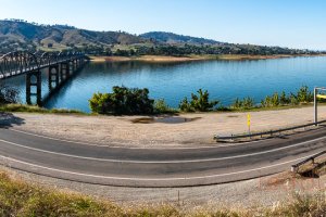
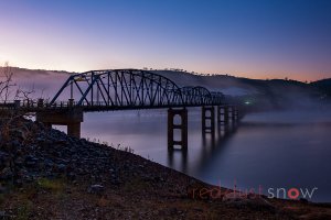
Panorama of the Bethanga Bridge that spans Lake Hume joining Greater Albury with the Victorian side of the Upper Murray
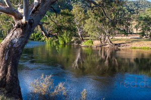
The Murray River at Gadd's Bend, located near Walwa on the Murray River. Upper Murray, Victoria, Australia.
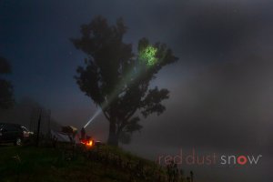
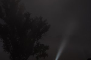
Night Glow at Gadds Bend, Dylan Robinson on the bank. Located near Walwa on the Murray River. Upper Murray, Victoria
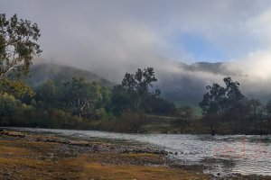
A misty winter's morning on the Upper Murray River at Gadds Bend near Walwa. Located downstream of Walwa on the Murray River. Upper Murray, NSW, Australia.
A misty winter's morning on the Upper Murray River at Gadds Bend near Walwa. Located downstream of Walwa on the Murray River. Upper Murray, NSW, Australia.
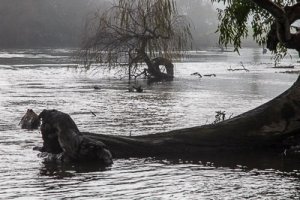
Looking downstream along the Murray River at Gadds Bend, camping. Located near Walwa on the Murray River. Upper Murray, Victoria
Looking downstream along the Murray River at Gadds Bend, camping. Located near Walwa on the Murray River. Upper Murray, Victoria
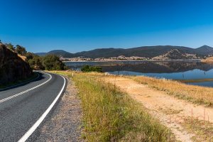
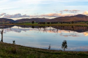
Lake Hume Sunset. Summer sunset and a beautiful reflection on the calm waters of Hume Weir at the end of the day at Lake Hume (Murray River) near Albury, NSW, Australia.
Lake Hume Sunset. Summer sunset and a beautiful reflection on the calm waters of Hume Weir at the end of the day at Lake Hume (Murray River) near Albury, NSW, Australia.
Lake Hume Sunset. Summer sunset and a beautiful reflection on the calm waters of Hume Weir at the end of the day at Lake Hume (Murray River) near Albury, NSW, Australia.
Lake Hume Sunset. Summer sunset and a beautiful reflection on the calm waters of Hume Weir at the end of the day at Lake Hume (Murray River) near Albury, NSW, Australia.
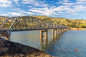
Bethanga Bridge that spans Lake Hume joining Greater Albury with the Victorian side of the Upper Murray
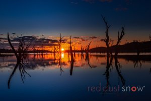
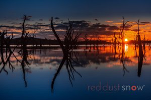
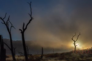
An Upper Murray River vista photographed during drought (2016). The original course of the Murray River is visible due to the low level of Lake Hume, NSW, Australia
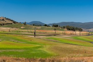
An Upper Murray River vista photographed during drought (2016). The original course of the Murray River is visible due to the low level of Lake Hume, NSW, Australia
An Upper Murray River vista photographed during drought (2016). The original course of the Murray River is visible due to the low level of Lake Hume, NSW, Australia
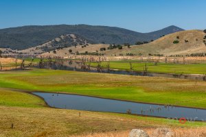
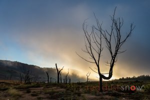
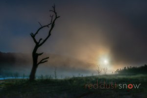
Photograph of the original course of the Murray River and original trees that lined the banks visible due to the low level of Lake Hume, NSW, Australia.
Photograph of the original course of the Murray River and original trees that lined the banks visible due to the low level of Lake Hume, NSW, Australia.
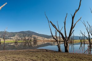
Photograph of the original course of the Murray River and original trees that lined the banks visible due to the low level of Lake Hume, NSW, Australia.
Photograph of the original course of the Murray River and original trees that lined the banks visible due to the low level of Lake Hume, NSW, Australia.
Photograph of the original course of the Murray River and original trees that lined the banks visible due to the low level of Lake Hume, NSW, Australia.
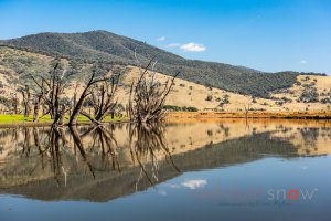
Photograph of the original course of the Murray River and original trees that lined the banks visible due to the low level of Lake Hume, NSW, Australia.
Photograph of the original course of the Murray River and original trees that lined the banks visible due to the low level of Lake Hume, NSW, Australia.
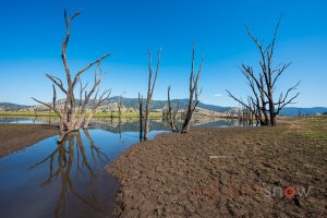
Photograph of the original course of the Murray River and original trees that lined the banks visible due to the low level of Lake Hume, NSW, Australia.
A misty winter's morning on the Upper Murray River at Gadds Bend near Walwa. Located downstream of Walwa on the Murray River. Upper Murray, NSW, Australia.
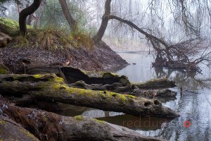
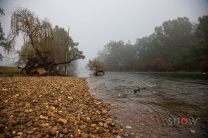
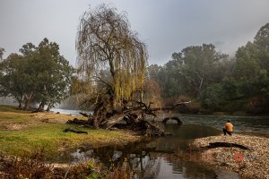
Willow in the morning mist at Gadds Bend, camping. Located near Walwa on the Murray River. Upper Murray, Victoria
Looking upstream along the Murray River towards Gadds Bend, camping. Located near Walwa on the Murray River. Upper Murray, Victoria
Looking upstream along the Murray River towards Gadds Bend, camping. Located near Walwa on the Murray River. Upper Murray, Victoria
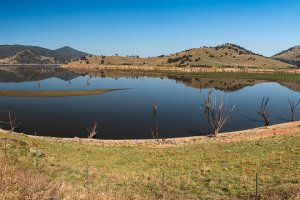
Upper Murray Vista photograph looking upstream from midway up Lake Hume from River Road, on the NSW side of the Murray River, Australia

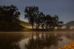
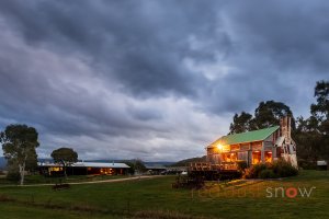
Night lights around the campsite at Gadds Bend. Gadd's Bend, located near Walwa on the Murray River. Upper Murray, Victoria, Australia.
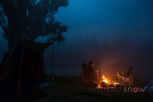
Night lights around the campsite at Gadds Bend. Gadd's Bend, located near Walwa on the Murray River. Upper Murray, Victoria, Australia.

Night lights around the campsite at Gadds Bend. Gadd's Bend, located near Walwa on the Murray River. Upper Murray, Victoria, Australia.
Night lights around the campsite at Gadds Bend. Gadd's Bend, located near Walwa on the Murray River. Upper Murray, Victoria, Australia.
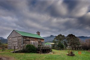
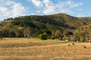
The Restored Slab Hut at Tom Groggin Station in the Victorian High Country
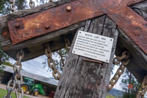
The commemorative cross in memory of Jack Reily at Tom Groggin Station in the Victorian High Country
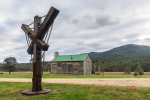
The commemorative cross in memory of Jack Reily at Tom Groggin Station in the Victorian High Country
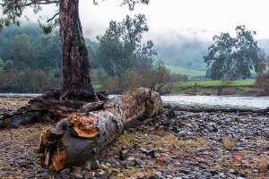
The Murray River at Tom Groggin Station, Victorian High Country
The historic hut at Tom Groggin Station, Victorian High Country
Night lights around the campsite at Gadds Bend. Gadd's Bend, located near Walwa on the Murray River. Upper Murray, Victoria, Australia.
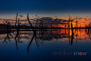
Lake Hume Sunset. Summer sunset and a beautiful reflection on the calm waters of Hume Weir at the end of the day at Lake Hume (Murray River) near Albury, NSW, Australia.
Horsehoe lagoon, an anabranch of the Murray River, downstream from Albury, on Australia's Victorian/New South Wales border.
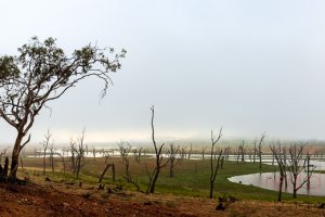
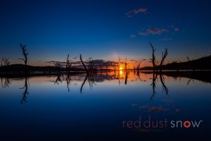
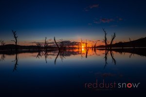
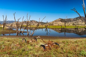
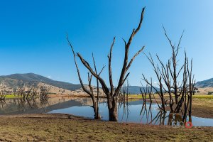
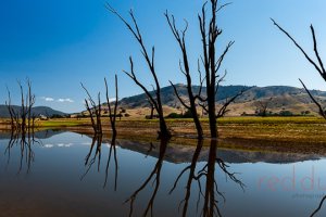
Spectacular winter's morning on the Upper Murray; during the recent drought, the low level of Lake Hume reveals the original course of the Murray River and the river gum trees that lined its banks.
Spectacular winter's morning on the Upper Murray; during the recent drought, the low level of Lake Hume reveals the original course of the Murray River and the river gum trees that lined its banks.

Spectacular winter's morning on the Upper Murray; during the recent drought, the low level of Lake Hume reveals the original course of the Murray River and the river gum trees that lined its banks.
Spectacular winter's morning on the Upper Murray; during the recent drought, the low level of Lake Hume reveals the original course of the Murray River and the river gum trees that lined its banks.
Spectacular winter's morning on the Upper Murray; during the recent drought, the low level of Lake Hume reveals the original course of the Murray River and the river gum trees that lined its banks.
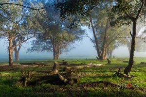
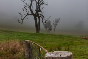
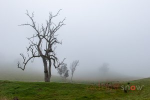
A morning mist creates a beautiful scene amongst the trees near Mount Granya, Upper Murray, Victoria, Australia.
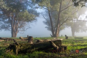
A morning mist creates a beautiful scene amongst the trees near Mount Granya, Upper Murray, Victoria, Australia.
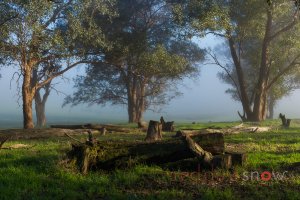
A morning mist creates a beautiful scene amongst the trees near Mount Granya, Upper Murray, Victoria, Australia.
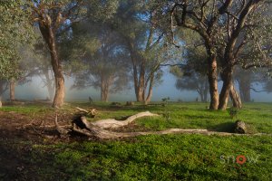
A morning mist creates a beautiful scene amongst the trees near Mount Granya, Upper Murray, Victoria, Australia.
The forest near Mt Granya, Upper Murray, comes back to life after the horrific bushfires during the summer of 2019/20. Mount Granya, Upper Murray, Victoria, Australia.
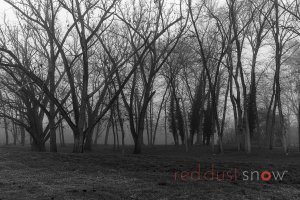
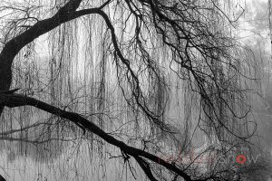
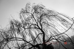
A beautiful winter scene (black and white photograph) of the deciduous trees at Noreuil Park, located beside the Murray River at Albury, New South Wales, Australia
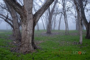
A beautiful winter scene (color photograph) of the deciduous trees at Noreuil Park, located beside the Murray River at Albury, New South Wales, Australia
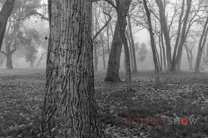
A beautiful winter scene (black and white photograph) of the deciduous trees at Noreuil Park, located beside the Murray River at Albury, New South Wales, Australia